A blueway is a designated water trail — usually a river, canal, or lake, though a small number of newer accredited routes cover sheltered sea sections too — with marked launch points, signed access, and walking or cycling tracks alongside. Ireland has more than a dozen of them, managed mostly by Waterways Ireland in partnership with local authorities, Fáilte Ireland, and Sport Ireland. They are a good way to start paddling in Ireland: gear demands are low and conditions tend to be more forgiving than open sea, though wind, water level, and cold still apply.
This guide maps every blueway open to paddlers, grades each one for difficulty, lists the launch points, and explains what gear and safety knowledge you actually need. It is written for Irish paddlers — beginners and improvers — who want to get on the water without sea-state, swell, or surf.
2026 Season Update
Route conditions, signage, and access rules on Irish blueways change during the season — lock works, towpath resurfacing, and estate access policies are all managed locally rather than centrally, and they don’t always make the news.
For up-to-date launch closures, water levels, and access rules, check Waterways Ireland’s marine notices before you paddle — they post wind, level, and lock-closure alerts there before anywhere else. For estate or park access, such as Crom on the Erne system, check the landowner’s own current visitor information rather than relying on what worked last season.
What Is a Blueway?
A blueway is a multi-activity recreational trail centred on a body of water. The official Waterways Ireland definition covers three uses: paddling, walking, and cycling. Each blueway has marked entry and exit points, signed access, and — where the corridor allows — a parallel greenway path for walkers and cyclists. Some blueways are flat-water canals or canalised rivers. Others are lake networks where the trail links bays, islands, and shoreline launch points.
The first official blueway in Ireland was the Shannon Blueway, launched in 2014 between Drumshanbo and Carrick-on-Shannon in County Leitrim. Since then the network has expanded to cover sections of the Shannon, Royal Canal, Barrow, Suir, Boyne, Erne, and several lake systems. New routes continue to be added as local authorities and Waterways Ireland develop the model.
Who designates them?
Most Irish blueways are designated and managed by Waterways Ireland, the cross-border body responsible for inland navigations on the island. Local authorities, tourism agencies, and community groups partner with Waterways Ireland on signage, parking, hire facilities, and trail maintenance.
Designated vs accredited
Not every route called a “blueway” carries the same status. The Blueway Partnership — Fáilte Ireland, Sport Ireland, Waterways Ireland, Sport Northern Ireland, and Tourism Northern Ireland — formally accredits routes against a shared technical and safety standard. As of 2026, four blueways hold that accreditation: the Suir Blueway (Tipperary), Lough Derg Blueway, and Boyne Blueway, accredited in April 2022, and the Arranmore-Burtonport Blueway in Donegal, Ireland’s first coastal blueway, accredited in 2023. The Shannon, Royal Canal, Barrow Line, Lough Lene, and Erne System blueways covered below are Waterways Ireland-designated paddling routes rather than accredited under the same scheme — a useful, signed route either way, but not the same status.
What blueways are not
Most are not white water and most are not open sea kayaking or adventurous expeditions — the exception is Arranmore-Burtonport in Donegal, an accredited blueway that includes sea sections. A blueway is generally a signed paddle trail with reliable launch infrastructure, chosen to lower the barriers for new paddlers, families, and accessible-paddling groups. That infrastructure does not remove the need to check wind, water level, and forecast before you launch. Anyone who has watched paddlers struggle to find a launch on a remote lake will understand why the infrastructure matters.
Blueways and Greenways — How They Differ
The two words sound similar and the trails often run side by side, but they cover different uses.
A greenway is a walking and cycling route. It runs on a hard surface — typically a former rail line, towpath, or canal-side path. The Great Western Greenway in Mayo and the Waterford Greenway are the best-known examples. Greenways are for feet and wheels, not boats.
A blueway is for paddlers. It runs on the water itself — canal, river, or lake — and is signed and serviced for kayak and stand-up paddle board (SUP) use. Most blueways have a greenway running parallel along the bank, so a paddler and a cyclist can travel the same corridor at the same pace, taking the same lunch break at the same village.
Where the two converge, you get a true multi-activity corridor. The Shannon Blueway, the Royal Canal, the Barrow Line, and the Suir Blueway are all paired with greenways. That is part of the appeal: a group can split into paddlers and cyclists for the day and meet at the next lock or village.
How to Read the Blueway Map
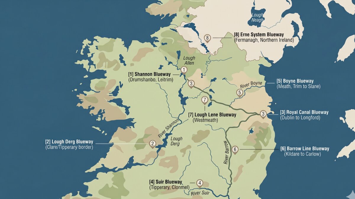
The map at the top of this article shows the main designated blueways open to paddlers as of 2026. Numbers refer to the route entries below.
| # | Blueway | County / Region | Paddle distance | Type | Suits |
|---|---|---|---|---|---|
| 1 | Shannon Blueway (Drumshanbo–Carrick-on-Shannon) | Leitrim | ~16.5 km | Canal + river | Beginners, families (one Advanced-graded stretch at Battlebridge Lock) |
| 2 | Lough Derg Blueway | Clare / Tipperary / Galway | Multi-bay, network | Lake | Beginners (sheltered bays), intermediate (crossings) |
| 3 | Royal Canal Blueway | Dublin → Longford | ~146 km full length, sectioned | Canal | Beginners, distance paddlers |
| 4 | Suir Blueway | Tipperary | 53 km paddling, 21 km cycle | River (flat) | Beginners, families |
| 5 | Boyne Blueway | Meath | Sectioned | River | Beginners, history-curious |
| 6 | Barrow Line Blueway | Kildare → Carlow | Sectioned | Canal + canalised river | Beginners |
| 7 | Lough Lene Blueway | Westmeath | Lake loop | Lake | Beginners |
| 8 | Erne System Blueway | Fermanagh (NI) → Cavan | Network | Lake + river | All levels |
Distances are paddleable segments — the parallel greenway path is sometimes longer. Always check the Waterways Ireland site for the current operational status of any route before travel: trail openings, closures for maintenance, and water-level advisories change through the year.
Every Blueway in Ireland — Reviewed
This section walks through the designated blueways one by one, with launch points, distance, what to expect on the water, and where to hire a boat if you do not own one.
Shannon Blueway — Drumshanbo to Carrick-on-Shannon
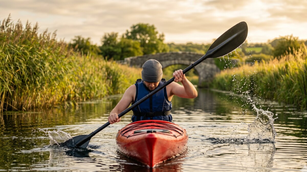
The original. Launched in 2014 as Ireland’s first official paddle trail. The Shannon Blueway runs along the restored Lough Allen Canal from Drumshanbo south through Acres Lake, Drumleague Lock, and Battlebridge Lock to Leitrim Village and on to Carrick-on-Shannon — 16.5 km in total. Most of it is flat water, but Waterways Ireland grades the short stretch where the canal meets the river at Battlebridge Lock as Advanced, with challenging currents. The canal sections are narrow — barely two kayak widths in places — with reed-fringed banks and restored stone bridges every couple of kilometres.
Launch points: Drumshanbo Lock (north end, full facilities, parking, toilets), Acres Lake jetty, Battlebridge Lock, Leitrim Village quay, Carrick-on-Shannon (south end).
Suits: beginners, families, accessible groups. The whole route is sheltered, signed, and serviced.
Hire: boats and SUPs available from the local outfitter in Drumshanbo through the summer season.
For a deeper read on this route and what to expect on the water, see the WaterEgo route page for the Shannon Blueway.
Lough Derg Blueway
Lough Derg is the largest lake on the Shannon system, sitting at the southern end of the navigable river and bordering Clare, Tipperary, and Galway. The Lough Derg Blueway is not a single linear trail — it is a network of designated paddling bays, launch points, and shoreline accesses around a lake roughly 39 km long.
Sheltered bays on the Tipperary side — Garrykennedy, Ballina, Dromineer — are the standard beginner picks. The Clare shore between Killaloe and Mountshannon offers slightly more open paddling with views across to the Galway side. Inis Cealtra (Holy Island), about 2 km off Mountshannon, is the natural turn-point for a half-day paddle and holds a remarkable collection of early Christian ruins including a 24-metre round tower.
Lough Derg is busy with motor cruisers all summer. Keep to the inshore 10 kph zone marked by yellow buoys, and listen for engines — sound carries strangely over open water. For the full route guide, see Lough Derg.
Launch points: Killaloe (Co. Clare), Garrykennedy, Dromineer, Mountshannon, Portumna (each has parking and a slipway).
Suits: beginners in the sheltered bays, intermediate paddlers on the open crossings.
Royal Canal Blueway — Dublin to Longford
The Royal Canal was built between 1790 and 1817 to connect Dublin to the Shannon at Cloondara, Co. Longford. The full canal is roughly 146 km long. Most of it is paddleable, and the Blueway designation covers signed launch points from Dublin out through Maynooth, Enfield, Mullingar, and onwards to the Shannon.
The canal is dead flat — no current, no waves, no tidal considerations. Several Georgian-era locks punctuate the route, and Waterways Ireland’s own guidance is to get out at any waiting jetty near a lock, since turbulence there makes locks too dangerous to paddle through — plan for a portage at each one rather than assuming you can pass through. The 16 km Maynooth–Enfield stretch is the standard one-day intermediate paddle, taking in canal-side villages with food and parking. Beginners typically pick a shorter 5–8 km section out from one harbour and back.
For the full Maynooth–Enfield route, see Royal Canal.
Launch points: Dublin (Spencer Dock through Phibsborough), Castleknock, Maynooth Harbour, Kilcock, Enfield, Mullingar Harbour, Abbeyshrule, Cloondara.
Suits: beginners, distance paddlers, anyone who likes infrastructure (lockkeeper’s cottages, pubs, cafés along the route).
Suir Blueway — Cahir to Carrick-on-Suir
The Suir Blueway runs along the River Suir in south Tipperary. Official tourism figures put the paddling trail at 53 km between Cahir and Carrick-on-Suir, through Clonmel, with a shorter 21 km cycling and walking route running the Clonmel-to-Carrick-on-Suir stretch alongside the river. Most of the paddling trail is gentle water with riffles in places. The parallel greenway runs along the towpath, which means a split-group day with paddlers on the water and cyclists on the bank works neatly here.
Launch points: Cahir town quay, Ardfinnan, Newcastle, Clonmel Quays, Kilsheelan, Carrick-on-Suir.
Suits: beginners and families. The Clonmel-to-Kilsheelan section is short, flat, and well-supplied for a half-day outing.
Hire: kayaks and SUPs available from the outfitter at Clonmel Quays in the summer season.
Boyne Blueway
The Boyne flows east through Meath, past Trim, Navan, Slane, and on to Drogheda. Sections of the river are designated and signed as the Boyne Blueway, with launch points at the towns and at heritage sites. The river is graded mostly flat with short gentle riffles in places, suitable for confident beginners.
This is the most history-rich Irish blueway: paddlers pass Trim Castle (the largest Anglo-Norman castle in Ireland), the Hill of Slane, and Newgrange in the distance. The water is generally clear by Irish standards because of the limestone catchment.
Launch points: Trim Castle (most popular), Navan, Slane.
Suits: beginners on the Trim section, history-curious paddlers on the full sequence.
Barrow Line Blueway
The Barrow is Ireland’s second-longest river, and the Barrow Line refers to the canalised section from Lowtown in Kildare south through Monasterevin, Athy, Carlow, and on to St Mullins where the navigation meets tidewater. Sections are designated blueway, with the Athy area and the lower Barrow valley being the most paddled.
The Graiguenamanagh-to-St Mullins stretch downstream of Carlow is the most popular section overall — see the WaterEgo route page for the River Barrow. Above that, the canal section is flat and slow with one short portage at Ballykeenan Lock.
Launch points: Athy town quay, Carlow, Bagenalstown (Muine Bheag), Graiguenamanagh, St Mullins.
Suits: beginners on the canal sections, intermediates on the lower Barrow where the current picks up after winter rain.
Lough Lene Blueway — Westmeath
Lough Lene sits in the middle of Westmeath, a clear-water spring-fed lake with three small wooded islands and a designated blueway access point on its northern shore. The lake is roughly 2 km across, sheltered on most sides, and small enough that a full circumnavigation is achievable in an afternoon.
Launch points: Pier B blueway slipway on the north shore (signed off the N52).
Suits: beginners, families, anyone wanting a single-session lake paddle.
Erne System Blueway
The Erne system covers Upper and Lower Lough Erne in Fermanagh, with extensions through Belturbet and the upper navigations into Cavan. This is the largest blueway network on the island by area, with dozens of launch points, scores of small islands, and the cross-border nature reserve at Crom Estate.
Upper Lough Erne is the more sheltered side — a maze of channels, drumlin islands, and creeks that suits beginners. Lower Lough Erne is bigger water with longer fetch and more wind exposure, recommended for intermediate paddlers.
Launch points: Enniskillen quay, Belleek, Castle Archdale Marina, Crom Estate, Belturbet, Quivvy Lough.
Suits: all levels, depending on where on the system you launch.
Other Designated Blueways Worth Knowing
A few smaller or newer routes carry blueway status without sitting in the headline list above. Status changes year to year, so check the Waterways Ireland site before travel.
- Mid-Shannon Wilderness Blueway — Lanesborough to Athlone, lake and river paddling through the Shannon Callows.
- Lough Allen — the upper Shannon lake, accessed through the Acres Lake channel north of Drumshanbo. Part of the wider Shannon Blueway network. See the WaterEgo Lough Allen route for the recommended western-shore paddle.
- Lough Key — connected to the Shannon by the Boyle River, with a marina at Lough Key Forest Park. Strictly the lake is a Shannon-connected paddle rather than a standalone blueway designation, but the facilities are equivalent.
How to Use a Blueway
Every blueway is laid out the same way: a signed launch point, parking nearby, an information board listing distance and grade, and (on most) toilet facilities and a parallel walking path. The signage is colour-coded for difficulty and tells you the next take-out and the distance.
The standard etiquette is straightforward:
- Park considerately. Blueway car parks fill up in summer. Block no-one in.
- Launch on the slipway, not the bank. The bank gets churned to mud quickly and damages the habitat.
- Keep right on canals. Other boats — and the occasional service barge — pass on the left.
- Yield to commercial traffic. Hire cruisers on Lough Derg or the Erne have less room to manoeuvre than a kayak. You move, not them.
- Take your rubbish home. Bins at launch points are not always emptied promptly. Cuts down on the visible litter that puts new paddlers off.
- Check Clean Dry between waters. Invasive species — zebra mussel, curly waterweed, killer shrimp — spread on kayaks. Rinse, drain, and let your boat dry between catchments. Inland Fisheries Ireland runs the Check Clean Dry campaign.
Safety on a Blueway
Blueways are easier than sea kayaking, but cold water is still cold and Irish weather still changes. Three rules cover most of what goes wrong.
1. Wear a buoyancy aid
A PFD (personal flotation device, also called a buoyancy aid) is not optional on a blueway. Irish lakes and canals stay cold most of the year, and cold-water shock can incapacitate a swimmer within a minute even in summer. Hire outfitters supply PFDs as standard. If you own a boat, your PFD lives on you, not in the boot.
2. Check the wind
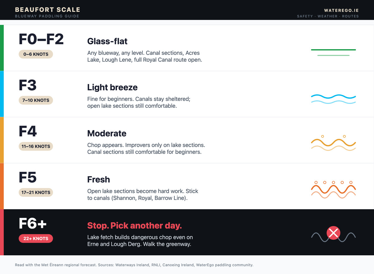
Wind affects blueways unevenly. Narrow canal sections stay calmer for longer, but open water — Acres Lake, Lough Derg, the Erne lakes, Lough Lene — develops chop as wind rises, and how much it affects you depends on fetch, wind direction, and your own ability, not wind speed alone. The Beaufort numbers below are a general guide, carried over from sea kayaking practice, not a guarantee for any specific day:
| Beaufort | Knots | What it typically does on a blueway lake |
|---|---|---|
| F0–F2 | 0–6 | Glass-flat to light ripple. |
| F3 | 7–10 | Light breeze. Small waves start. |
| F4 | 11–16 | Moderate. Chop builds on open water. |
| F5 | 17–21 | Fresh. Open lake sections get hard work. |
| F6+ | 22+ | Strong. Reassess before launching. |
Met Éireann publishes a regional forecast that covers wind direction and speed for every county. Read it the morning of your paddle.
3. Tell someone where you are going
The simplest safety habit is the float plan. Tell a friend the launch point, the planned route, and the expected return time. If you are not back by then, they call for help. The Irish Coast Guard runs the 999/112 emergency number on inland waters as well as the coast.
Weil’s disease and water quality
Canal and slow-river water in Ireland can carry leptospira bacteria, which cause Weil’s disease — a flu-like illness that turns serious in rare cases. The practical rules are: cover any open cuts before paddling, wash hands before eating, and rinse off after a capsize. The risk is real but very low if basic hygiene is followed.
Cold-water shock
Irish inland water temperatures peak around 18°C in August on shallow canals and barely 14°C in deeper lakes. From October through May, expect single digits. Cold-water shock — the gasp reflex on sudden immersion — is the single biggest killer of unprepared swimmers in Irish waters. Wear a wetsuit in cold months. Carry spare dry clothes in a dry bag. Do not paddle solo in winter.
Gear for a Blueway
Blueway paddling is forgiving on kitlist. A basic secondhand setup can be inexpensive if you shop around, or you can hire everything you need for a day without owning any of it — see hire costs further down.
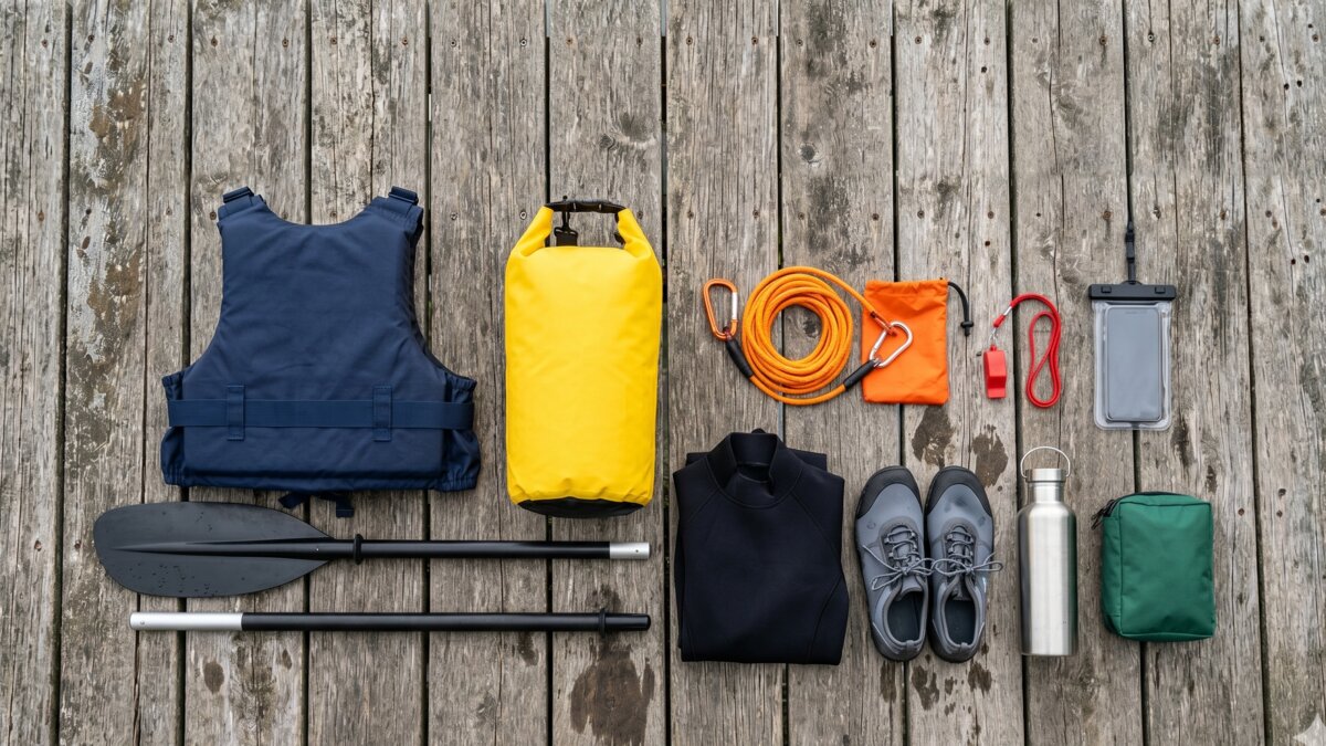
The minimum kit for a day blueway paddle:
- Sit-on-top kayak, sit-inside kayak, or SUP. Any of the three works. SUPs are the fastest-growing option.
- Paddle. Adjustable shaft is ideal so it suits multiple paddlers.
- PFD / buoyancy aid. ISO 12402-5 (Level 50) is the standard for flat-water paddling.
- Helmet. Optional on still water. Strongly advised on any moving-water section.
- Wetsuit or warm layers. Needed for most of the year in Ireland — go by the water and air temperature on the day, not the calendar.
- Spare clothes in a dry bag. Lashed to the deck or stored in the dry hatch.
- Whistle. Mandatory on hire boats; useful on your own boat.
- Phone in a waterproof case. For navigation and emergency calls.
For a longer or multi-day trip, add a spray deck (sit-inside only), a tow line, a paddle leash, water and food, and a basic first-aid kit.
What blueway paddling does not need
- A sea kayak. Wrong tool — too long for narrow canal turns, too expensive for the use case.
- A drysuit isn’t usually necessary for a short summer paddle in mild conditions. For a longer trip, colder water, or a colder time of year, weigh it against how long you’d be immersed if you capsized rather than ruling it out by season.
- A VHF radio isn’t the norm for blueway paddling, since most routes stay within mobile phone reception. Coverage isn’t guaranteed everywhere on every inland stretch, though, so check signal for your specific launch and carry a phone in a waterproof case as your baseline.
Cost — Trail Free to Paddle, Hire Costs Extra
Paddling a blueway is not normally charged in itself, and most launch points have no parking fee. Where there is a fee — Lough Key Forest Park, for example — it is a parking charge that funds the marina, not a paddling charge. Waterways Ireland also runs a permit system covering locks and mooring on the Barrow Navigation, Grand Canal, and Royal Canal, and some estates set their own access conditions — Crom on the Erne system is one. Check the current rules for your route before you rely on free access; the blueway branding on a sign does not itself guarantee it.
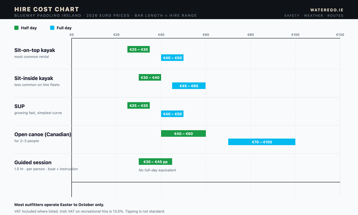
Hire costs from Irish outfitters in 2026 typically sit in these ranges:
| What you hire | Half day | Full day | Notes |
|---|---|---|---|
| Sit-on-top kayak | €25–€35 | €40–€50 | Most common rental |
| Sit-inside kayak | €30–€40 | €45–€60 | Less common on hire fleets |
| SUP | €25–€35 | €40–€50 | Growing fast, simplest learning curve |
VAT is included in the listed price in most cases — Irish VAT on recreational hire is 13.5%. Tipping a guide is not the standard. Most hire outfitters operate Easter to October only.
Best Time of Year
The blueway season runs roughly Easter through October. Inside that window:
- April–May — quiet, water still cold, hire fleets opening up. Pick a sheltered route. Wear a wetsuit.
- June — the sweet spot. Long evenings, water warming, low cruiser traffic, hire fully operational.
- July–August — peak. Routes busy on weekends. Book hire ahead. Cruiser traffic on lake blueways is at its highest.
- September — second sweet spot. Water still warm, evenings shorter, far fewer people.
- October — last of the season. Hire fleets winding down. Wetsuit weather.
Winter paddling is possible on the canal blueways — Shannon, Royal Canal, Barrow Line — but you need full immersion gear and the daylight window is short. Lake blueways are not recommended for casual paddlers from November to March.
Common Mistakes on a Blueway
Patterns we see at WaterEgo from new paddlers who message after a bad first outing:
- Underestimating wind on a lake. A F4 cross-wind on Acres Lake or Lough Lene catches paddlers who assumed “blueway” meant “easy”. It does not mean wind-free.
- Skipping the PFD because it is shallow. Drowning happens in any water. Wear the buoyancy aid.
- Not checking wind direction before launching. As a general rule, paddling into the wind on the way out and with it on the way back is easier than the reverse, but wind can shift during a paddle. Check the forecast for the whole session, not just the moment you launch.
- No spare clothes. A capsize 5 km from the car park and no dry layer turns a fun day into a hypothermia risk.
- Trying to do the full Royal Canal as a first paddle. Pick an 8 km out-and-back from one harbour. Build up.
- Ignoring Check Clean Dry. Moving a kayak from Lough Derg to Lough Lene without rinsing risks spreading invasive species. Both lakes are part of the same biosecurity advisory.
- Paddling solo in October on an open lake. Cold water plus no rescue partner is the highest-risk combination on this list.
Frequently Asked Questions
What is the difference between a blueway and a greenway?
A blueway is a paddling trail on the water — canal, river, or lake — with signed launch points and parallel walking access. A greenway is a walking and cycling path on land, usually on a former rail line or canal towpath. They often run together along the same corridor, which is where blueway and greenway projects pair up.
Are blueways in Ireland free?
Mostly. Paddling a blueway is not normally charged in itself. Some launch points sit inside paid car parks (Lough Key Forest Park, for instance), and Waterways Ireland runs a permit system covering locks and mooring on some canal sections, so check the current rules for your route. Hire of a boat or SUP is paid separately to the outfitter, typically €25–€50 for a half day.
How many blueways are there in Ireland?
There are eight headline blueways on the island in 2026, plus several smaller and newer routes. The Shannon, Lough Derg, Royal Canal, Suir, Boyne, Barrow Line, Lough Lene, and Erne systems are the main ones, though only four — Suir, Lough Derg, Boyne, and Arranmore-Burtonport in Donegal — hold formal Blueway Partnership accreditation; the rest are Waterways Ireland-designated routes. Waterways Ireland and Fáilte Ireland publish the current lists and any seasonal closures.
What is the easiest blueway for beginners?
The Shannon Blueway between Drumshanbo and Acres Lake is the standard first-paddle pick. Flat water, no current, full facilities at both ends, and 2–3 km of canal before you reach open water. The Suir Blueway around Clonmel and the canal sections of the Royal Canal are equally suitable.
Do I need a licence to paddle a blueway?
Generally not for casual, private kayak or SUP use, but it depends on the waterway and the landowner. Waterways Ireland runs a permit system for the Barrow Navigation, Grand Canal, and Royal Canal covering locks and mooring, and some estates and parks set their own access conditions. Check with Waterways Ireland or the relevant landowner rather than assuming.
Can I bring my dog on a blueway?
Yes, on the parallel greenway path. Dogs on kayaks and SUPs are a personal call: well-trained dogs travel happily on stable boats, but they must wear a buoyancy aid the same as the human paddler. Keep dogs leashed where the greenway crosses farmland with livestock.
What blueway has the best wildlife?
Crom Estate on the Erne system — beavers, white-tailed eagles (reintroduced), otters, kingfishers — has probably the richest mix. Lough Derg around Mountshannon has the longest-established white-tailed eagle nesting site in Ireland. Inis Cealtra (Holy Island) on Lough Derg combines wildlife with one of the most evocative early-Christian sites in the country.
Final Word — Which Blueway Should You Start With?
If you have never paddled before, start on the Shannon Blueway at Drumshanbo. Flat water, no current, full hire on-site, parking, toilets, and a 2 km canal stretch before you reach any open water. Pick a settled day in June or September. Wear a buoyancy aid. Tell someone your plan.
If you have paddled a few times and want more space, move to Lough Derg’s sheltered Tipperary bays — Garrykennedy or Dromineer — and build up to the Holy Island crossing once the wind is settled. If you live near Dublin, the Royal Canal from Maynooth gives you 16 km of flat farmland water without leaving Kildare.
The whole point of the blueway network is that it removed two of the biggest barriers to Irish paddling: not knowing where to launch, and not having confidence in the water. Every blueway in this guide is signed and has reliable launch infrastructure, though the right route for you on the day still depends on your own experience, the forecast, and how far you want to go. Pick one, check the conditions, go. The next one is easier than the first.
Also Read
- Kayaking for Beginners Ireland — Your First Paddle Guide — the prerequisite if you have never paddled. Read this before launching on any blueway.
- Kayak Rental Ireland — 54 Verified Operators by County + What It Costs (2026) — every rental yard on every Irish blueway and coast, with current 2026 prices.
- Kayaking Clubs in Ireland — 45 Verified Clubs by County + How to Join (2026) — find the kayaking club closest to your nearest blueway and the cost of joining it.
- Kayaking West Cork — Complete Paddler’s Guide — the sheltered-bay sea-paddling counterpart for the south coast.
- Sea Kayaking Ireland — The Complete Paddler’s Guide — the saltwater counterpart to this article, with weather, rescue, and route advice for the Irish coast.
- Shannon Blueway route page — the original Irish blueway, full launch and route detail.
- Lough Derg route page — biggest lake on the Shannon, sheltered bays for beginners and open crossings for improvers.
- Royal Canal route page — Maynooth to Enfield, 16 km of flat canal water through Kildare farmland.
- River Barrow route page — Graiguenamanagh to St Mullins, 9 km of canalised river ending at tidewater.
No comments yet on this guide.
Be the first to share your experience — conditions, access, hazards, or anything a future paddler should know.
Login to join the discussion